HOW DO WE GO ABOVE AND BEYOND
we go ABOVE
24/6 Processing & Owned Air and Marine Assets
Company-owned aircraft and vessels, paired with 24/6 in-house processing, enable faster mobilization and turnaround.
Verified Accuracy with World-Standard Equipment
Ground validation and fully owned, world-standard equipment ensure precision from data acquisition to delivery.
End-to-End Support
You'll be supported by a dedicated project engineer who ensures your needs are translated into a tailored strategy, custom proposal, and seamless execution
Custom Proposals
Each proposal is thoughtfully crafted to reflect the scope, complexity, and goals of your project with full transparency and fair pricing based on your actual needs.
and BEYOND
Strategic Comprehensive Solutions through Partnerships
We collaborate with technical experts to deliver comprehensive, decision-ready data you can trust.
Partnered with GIS Software
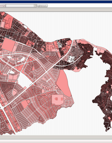
GIS tools transform complex datasets into actionable maps supporting smarter decisions in infrastructure, environmental, and engineering projects.
Partnered with Geo-Professionals
We collaborate with geo-professionals from various disciplines to tackle the most complex land and sea mapping challenges.
Partnered with Wind LiDAR Provider
We’re proud to stand with the CRETC network to promote sustainable, data-driven development.

OUR CLIENTS
OUR SERVICES

We're #TheLiDARGuys
Mapped 200K+ Hectares with LiDAR | 25+ Years of Surveying Expertise | Trusted by Industry Leaders
What to expect when working with us?
End-to-End Support
You'll be supported by a dedicated project engineer who ensures your needs are translated into a tailored strategy, custom proposal, and seamless execution
Company-owned aircraft and vessels, paired with 24/6 in-house processing, enable faster mobilization and turnaround.
24/6 Processing & Owned Air and
Marine Assets
We collaborate with technical experts to deliver comprehensive, decision-ready data you can trust.
Comprehensive Solutions through Partnerships
Verified Accuracy with World-Standard Equipment
Ground validation and fully owned, world-standard equipment ensure precision from data acquisition to delivery.


